
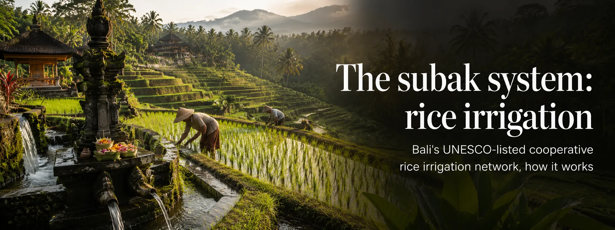
Subak is one of the words travel guides love using beside a photograph of green rice terraces, then quietly forgetting to explain. It is not the terrace itself. It is the living farmer organisation and water-management system that helps make those landscapes possible.
I think Bali becomes much more interesting once you start noticing the canals, weirs, temples and cooperation behind the view. The rice field is the visible result; subak is part of the human system underneath it.
01 Subak is an organisation, not another word for rice terrace
Visitors often hear subak used as if it simply means terraced rice field. It does not. A subak is a cooperative association through which farmers coordinate irrigation and agricultural responsibilities. The visible terraces are one result of that system, not the system itself.
This distinction matters to me: terrace is landscape; subak is organisation. Mixing them up turns a sophisticated social system into a photography label.
That distinction changes how you look at the landscape. The canals beside a road, small diversion gates, temple compounds, forested water sources and farmers working plots at different levels are connected. A green panorama that looks effortless from a café is actually managed infrastructure.
02 How water moves downhill without one farmer taking it all
Bali’s volcanic mountains capture rainfall and feed springs and rivers. Water is diverted through channels, tunnels, weirs and smaller canals into rice-growing areas. Because fields sit at different elevations and belong to different farmers, allocation has to be coordinated rather than left to whoever is upstream.
Water makes the hierarchy visible. I watch where it enters, divides and moves downhill, because that is where the cooperative problem becomes real.
Subak rules help determine timing, maintenance and distribution. The system also allows farmers to coordinate planting and fallow periods, which can help manage pests and water demand. It is not a museum technology: channels are cleaned, gates adjusted and decisions negotiated as part of working agriculture.
03 The farmer cooperative behind the landscape
Each subak is a social institution as well as a hydraulic one. Members meet, maintain shared infrastructure and operate through locally agreed rules. UNESCO describes the wider tradition as democratic and egalitarian water management focused on water temples and irrigation control.
That does not mean every decision is conflict-free. Water is valuable, tourism changes land values and agriculture competes with development. The achievement is that coordination occurs across many separate holdings and, in larger temple networks, across watersheds rather than only within one farm.
04 Why water temples are part of the practical system
Water temples are not decorative additions to an irrigation project. Ritual and water management are intertwined. Temples mark important water sources and points in the network, while ceremonies connect farming cycles with religious life and community obligations.
The temple element is why subak is more than an irrigation committee. Practical water management and religious life sit in the same system.
At the largest scale, the Supreme Water Temple at Pura Ulun Danu Batur is associated with Lake Batur, regarded in the UNESCO cultural landscape as an ultimate source of springs and rivers. Smaller temple relationships extend through local systems. The sacred and practical layers cannot be neatly separated.
05 Tri Hita Karana: a useful idea, not a tourism slogan
Subak is commonly explained through Tri Hita Karana, the Balinese principle of harmonious relationships involving the divine, people and the natural world. UNESCO uses the concept in the World Heritage listing because water, religious practice, community cooperation and ecology are visibly linked in the landscape.
Tourism businesses sometimes use the phrase as a generic synonym for sustainability. The subak context is more concrete: farmers need functioning water sources, collective rules, maintained channels and ritual institutions. Harmony is not just an aesthetic mood; it requires ongoing labour and cooperation.
06 What UNESCO actually inscribed in 2012
UNESCO did not list every rice terrace in Bali. The Cultural Landscape of Bali Province covers five component areas totalling about 19,500 hectares, chosen to demonstrate the interconnected natural, religious and social elements of the subak system.
UNESCO did not simply reward Bali for having attractive rice fields. The inscription is about a cultural landscape and the institutions that shaped it.
Components include the Pakerisan watershed, Catur Angga Batukaru landscape, Pura Taman Ayun and the Ulun Danu Batur water-temple landscape. Jatiluwih is part of the Catur Angga Batukaru component. Tegallalang, although famous and beautiful, is not itself one of the listed World Heritage components.
07 Why the fields do not stay bright green
Rice terraces change through planting, growing, harvest and preparation. A famous viewpoint can therefore be mirror-like with young seedlings, intensely green, gold before harvest or muddy and recently cut. None of those stages means you arrived at the wrong time; they are evidence that the fields are farms.
Different plots can also be at different stages. Do not trust social-media posts promising a precise island-wide “green season”. Rain, water availability, local decisions and planting schedules vary. If a particular landscape matters to you, enjoy the agricultural reality rather than expecting a permanent postcard.
08 A living system under real pressure
UNESCO has repeatedly identified pressures including land conversion, changing livelihoods and the need to support farmers so traditional systems remain viable. Tourism can bring income but also raises land values and creates demand for villas, roads and other development.
A living system can be beautiful and still be under pressure. Development, land conversion and tourism all matter more than whether the terraces look green this week.
Water demand is another reason visitors should avoid romanticising the terraces as untouched heritage. Hotels, households, agriculture and businesses all rely on finite resources. Supporting local guides, paying legitimate access contributions and staying on marked paths is more useful than treating a working field as a free photo studio.
09 Where to see subak clearly
Jatiluwih is the most obvious visitor-friendly place because large walking routes make the irrigation landscape easy to read. Around Tampaksiring and the Pakerisan valley you can connect water, temples and archaeology. Quieter rice areas around Sidemen and rural Tabanan also show how canals and cultivation shape village landscapes.
Jatiluwih is the obvious place to see the landscape at scale, but I look for subak clues almost anywhere rice farming and water channels are still active.
When walking, stay on public or marked paths, do not trample bunds between paddies and ask before entering working fields. Small channels can be deeper or faster than they look. Drones can disturb residents and may be restricted, so do not assume rural scenery is an unrestricted launch zone.
10 What to remember when you look at a rice terrace
A Balinese rice terrace is not just an engineered slope and not just a sacred landscape. It is part of a network in which water, farming, cooperative decisions, temples and environmental conditions interact.
Once you understand subak, the scenery becomes more interesting. You notice channels as infrastructure, temples as part of water governance, farmers as members of a cooperative system and the changing colour of fields as an agricultural cycle. That is much closer to the living Bali UNESCO set out to recognise.
TATS Man bottom line: Subak is the organisation behind the postcard: farmers coordinating water, ritual and agriculture across a shared landscape. Once you understand that, Bali’s rice terraces stop being scenery and start telling you how the island works.
Cheers, Carpe Diem & Follow the Water, Not Just the Instagram! 🍻⏳💧
your canal-watching, rice-system-nerding subak cyborg
About the author
TATS Man
Travel journalist · digital nomad since 2007 · visiting Bali since 1989
TATS Man is the beer-loving cyborg travel journalist behind Totally Bali and TATS (Totally Awesome Travel Sites). He has travelled and worked remotely since 2007 and has been visiting Bali since 1989. His guides combine long-term destination familiarity with current primary-source research — and he does not claim first-hand experience where he does not have it.